We deliver local knowledge backed by global strength.
With presence across the continents, we enable our member firms to deliver services that are locally relevant and globally aligned with international standards.

Our Network
Our Network
Insights
Insights
Business Insights providing executives with straightforward and strategic perspectives on key challenges: reshaping business models, addressing climate change and sustainability, and cultivating trust amidst rapid technological advancements.
All Insights
Services
Services
Our collaborative and transparent service portfolio includes assurance, business advisory, tax compliance and planning, risk assessment, and technology services. We prioritize integrity, objectivity, and confidentiality. With personalized strategies, we excel in meeting diverse client needs through a client-centric and proactive approach.
All Services
Industries
Industries
At PA Global, we stand as your reliable partner in navigating today’s complex and evolving business landscape. Our team of seasoned professionals brings deep industry expertise and a commitment to delivering tailored, forward-thinking solutions that empower organizations to grow sustainably and operate with resilience.
All Industries

The Strait of Hormuz is one of the world’s most strategically significant maritime passages. Though only about 21 miles wide at its narrowest point, this narrow corridor links the Persian Gulf to the Gulf of Oman, the Arabian Sea, and the rest of the world, serving as the sole maritime outlet for the energy exports of several major oil- and gas-producing states. Roughly one-fifth of global seaborne oil and a substantial share of liquefied natural gas (LNG) transit this waterway each day, making it the most critical energy chokepoint in the global economy. Also, the strait is vital for the transportation of commodities essential to global supply chains and any disruption can lead to severe supply shortages.
What gives the Strait of Hormuz its exceptional geopolitical weight is not merely the volume of trade that passes through it, but the way geography, maritime routing rules, and coastal proximity combine to give Iran outsized influence over a legally international waterway.
The Strait of Hormuz is not dominated by Iran because of law or diplomacy,
it is dominated by Iran because ships cannot go anywhere else.
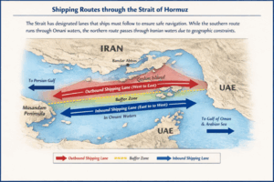
- The red lane represents the outbound shipping route (Persian Gulf → Gulf of Oman)
→ This lane runs closer to the Iranian coast and passes near Iranian-controlled islands. - The blue lane represents the inbound shipping route (Gulf of Oman → Persian Gulf)
→ This lane lies largely in Omani waters. - The yellow dashed area is the buffer zone, which vessels are prohibited from entering except in emergencies.
A Strait Shared by Many, but Constrained by Geography
Geographically, the Strait of Hormuz lies between Iran to the north and the Musandam Peninsula of Oman, with the United Arab Emirates situated slightly to the southwest. While the strait appears relatively broad when measured from coastline to coastline, the portion that is actually usable by large commercial vessels is far narrower.
Ultra-large crude carriers and LNG tankers require deep, carefully managed channels to operate safely. As a result, international maritime authorities established a Traffic Separation Scheme (TSS) consisting of two shipping lanes, one inbound and one outbound, each approximately two miles wide and separated by a two-mile buffer zone. These lanes define where ships can legally and safely sail.
Crucially, there is no practical alternative routing within the strait. Outside the designated lanes, waters quickly become unsuitable due to shallower depths, navigational hazards, island clusters, and heavy military and commercial congestion. This means that, in operational terms, ships must follow a fixed maritime corridor regardless of political borders.
Routes Cannot Be Shifted Away from Iran
Although the Strait of Hormuz is bordered by Iran, Oman, and the United Arab Emirates (UAE), at several points, navigable waters fall either partially or entirely within Iran’s territorial sea. This is not a political choice, but a geographic constraint and the shipping routes cannot be freely relocated for several reasons:
- Geography and Water Depth: Large oil tankers and LNG vessels require deep, predictable waters. Outside the designated lanes, depths quickly become unsuitable due to underwater topography and island clusters.
- Coastline Shape
- Iran’s coastline curves around the northern side of the strait and is dotted with strategic islands such as Qeshm, Larak, and Hormuz
- Oman’s Musandam Peninsula forms a narrow, jagged southern boundary
These two coastlines effectively funnel maritime traffic into a fixed corridor.
- Mandatory Routing Discipline: Commercial vessels, insurers, and flag states all require strict adherence to the TSS. Deviating from it would increase collision risk and void insurance coverage, even in peacetime.
In effect, even though the strait has multiple bordering states, geography forces international shipping into proximity with Iran. As a result, at certain choke points, ships have no navigable option but to pass through or alongside Iranian territorial waters, regardless of political preference. No alternative sea lane exists that would allow tankers to bypass Iranian waters while remaining safe, legal, and commercially viable.
International Law vs. Strategic Reality
Legally, the Strait of Hormuz is governed by the United Nations Convention on the Law of the Sea (UNCLOS), which guarantees the right of “transit passage” through international straits. Under this framework, coastal states are not permitted to impede passage as long as vessels transit continuously and peacefully.
However, legal rights do not eliminate strategic leverage. Iran maintains extensive naval infrastructure along its northern coast, including bases near Bandar Abbas, surveillance installations on key islands, and a highly active naval force capable of asymmetric operations. This proximity allows Iran to monitor, shadow, harass, or threaten shipping without formally closing the strait, actions that alone can be sufficient to deter insurers, raise freight costs, or divert traffic.
Past crises have demonstrated that the mere perception of risk, rather than an actual blockade, can dramatically reduce traffic through the strait. In several instances, commercial shipping avoided the passage following Iranian warnings or limited incidents, underscoring how geography magnifies Iran’s influence beyond what international law alone would suggest.
Why Alternatives Cannot Replace Hormuz
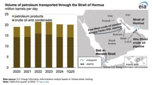
To reduce dependence on the strait, some Gulf states have invested in overland pipelines, such as Saudi Arabia’s East–West Pipeline and the UAE’s Abu Dhabi Crude Oil Pipeline to Fujairah. While strategically important, these routes can carry only a fraction of the daily volumes typically shipped through Hormuz and are unavailable to many regional exporters, including Iraq, Kuwait, and Qatar.
As a result, Hormuz remains irreplaceable. The global energy system continues to depend on uninterrupted passage through a maritime corridor that geography has made narrow, congested, and strategically asymmetric.
A Chokepoint Defined by Geography, Not Ownership
No single country “owns” the Strait of Hormuz. Yet ownership is not the decisive factor. What matters is that geography dictates shipping behavior, and geography places Iran closer to the navigable heart of the strait than any other state.
This is why Iran’s influence over the Strait of Hormuz is structural rather than political. Even in times of stability, vessels cannot bypass Iranian-adjacent waters. In times of tension, this reality transforms the strait from a commercial artery into a global pressure point, one where local geography can shape global economic outcomes.
In the modern world, few places better illustrate how maps, not treaties, ultimately determine power at sea.
© 2026 PA Global. All rights reserved.